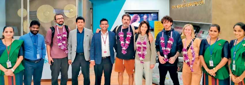
Visiting Israeli film crew at Bandaranaike International Airport with Frames TV & Film Productions and Sri Lanka Tourism officials
Feature film is expected to be screened in Israel and over 50 countries across Europe
UCM, Sri Lanka Tourism and Frames TV & Film Productions to co-produce film
SLTPB says project is a great opportunity to promote destination SL and mitigate ‘current negative publicity’ towards country
Israeli film production house United Channel Movies (UCM) is currently in Sri Lanka to shoot its latest feature film ‘Arugam Bay’ in the eastern region of the island nation.
The filming will start on May 3 and is expected to wrap up by May 22, the Sri Lanka Tourism Promotions Bureau (SLTPB) said in a statement to the media yesterday.
The main filming will be taking place in Arugam Bay, Colombo as well as in Tel Aviv – Israel. This film is expected to be screened in Israel and over 50 countries across Europe.
“I have been travelling to Sri Lanka for over 15 years and it is like a second home to me. The current situation facing Sri Lanka did not stop my return to the island and undertaking this film. We are happy to be back in Sri Lanka and I’m confident this film ‘Arugam Bay’ will gain greater success,” said Film Director Marco Camal while sharing his thoughts on filming in Sri Lanka.
While creating a greater promotion for the destination of Sri Lanka as well as the Eastern province as an unforgettable beach destination, with many adventure and leisure activities, the SLTPB said the Arugam Bay project expects to generate foreign revenue for the country’s economy.
The statement highlighted that the project is a great opportunity for Sri Lankan international film industry as well as for the inbound film tourism industry.
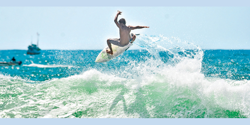
The film is about a young Israeli group travelling to Sri Lanka for surfing and life experiences. The film will also highlight the warm hospitality of Sri Lankan and the genuine love and care offered to foreigners in general, the SLTPB said.
Sri Lanka-based international film production company Frames TV & Film Productions will be joining hands with UCM Productions, Israel Film Commission and Sri Lanka Tourism to produce the film.
Sri Lanka Tourism and the partnering organisations expressed confidence in the popularity generated via this film helping to mitigate the ‘current negative publicity’ towards Sri Lanka and inspire more international productions to select the island nation as the most preferred tropical film destination.
The SLTPB said it supported the destination promotional film production as part of the ongoing International Film Tourism Promotions and expects to further promote the island as one of the leading film location destinations in South Asia.
The following morning looked gloomy with an overcast sky. The sounds of the birds were the same as on any other day. The river looked quite full. Most probably it had rained upstream, since the water looked like chocolate milk. Fortunately we had taken drinking water, which was used for cooking purposes. We had to be satisfied with the river water to wash ourselves. After a quick breakfast, the damage caused by the elephant was inspected. It was small wonder that nothing had happened to either engine. The mechanic who was brought from the village confirmed this, much to our relief.
It rained almost the entire day. It was miserable being in the campsite. In addition to all we had gone through, I found a garuda, which is a giant-sized centipede about six inches in length, crawling on our tent. It had rained so hard that some of the tents were falling apart as the earth to which they were tethered with spikes was soft and the roof of the tents was heavy with collected water. One tent was so full of water that certain personal belongings were floating inside. Even though it was miserable being at the campsite we had no choice but to wait till the police report regarding the accident was taken for insurance purposes.
The following day we decided to pack up and return home one day earlier. The police officers had told my husband that our vehicle had been about the twenty-fifth that had been damaged by elephants. We were later informed that the elephant, which damaged our vehicle, was being referred to as “Mitsubishi”, after the make of our pick-up.
After that fateful day I decided never to go to Wasgamuwa again, and none of us has been there since. Having nightmares about elephants chasing me is nothing new since that day. I doubt my ever wanting to go there again. With the experience we had, I personally think it would be a good idea for park officials to hand over flares to trackers to be used in an emergency.
National Parks around Arugam Bay
Having checked the maps for a couple of days and after consulting others, a decision was made to go to Arugam Bay through Tanamalwila. Though it was a longer route, the drive was supposed to be easier than via Belihul Oya. Seventeen of us, including three children, set off in three vehicles just before 3.30 am on our long journey on July 20, 2002. Traveling to these war-torn areas, which were out of bounds for 20 years, was made possible as a result of the on-going peace process.
On reaching Udawalawe we stopped at the causeway to watch a herd of elephants in the National Park grazing in the morning sun. Later on, as it became warmer, the herd gradually retreated into the jungle. Having broken journey and flexing our muscles at Udawalawe, we proceeded to our destination, of course breaking journey several times in between. There were people in our party who had never been to Arugam Bay all their lives. I was told that I had been to the place at a very young age but have no memories of it.
Lahugala
Eight miles before Potuvil is Lahugala National Park. I have visited the place as a child with my parents and brother. At the time I remember having stayed in the bungalow overlooking Lahugala tank. There were two rooms in the bungalow, one of which my elder brother and I shared. I also remember my brother waking me up early morning to show me elephants, which usually feed on beru grass. I was so sleepy that I found it difficult to keep my eyes open, but somehow managed to keep awake.
We were too scared to walk to the other room to wake our parents. We, therefore, kept an eye on the elephants, for which the tank was famous, till the sun came out. Lo and behold, was I not angry with my brother for having woken me up early and having kept me awake for so long, only to find that we had been staring at some huge rocks!
On our recent trip in July 2002, we learned that this bungalow had been demolished during the height of the war, with a few walls remaining. The rocks that were visible many years ago, were all covered with large trees that were growing around them. An army camp had been set up by the main road nearby. On our visit there were no barricades on the access road, but I am sure a couple of years ago no vehicles would have been allowed to pass the camp without permission, and hardly anyone would have dared to go that way either.
We were lucky to see quite a large herd of elephants in the far corner of Lahugala tank. At Kitulana tank, the other reservoir close by, we again managed to spot a few elephants feeding on the same type of grass.
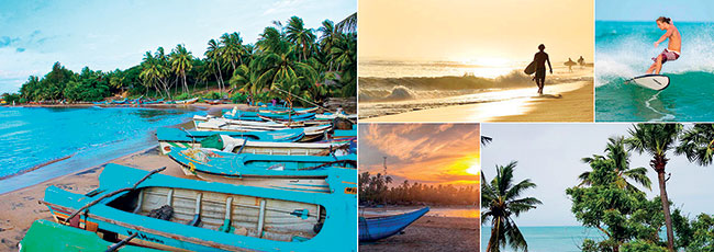
By lunchtime we reached Arugam Bay which has been internationally selected as one of the best places in the world for wind surfing. There were quite a number of tourists who were surfing and it was a welcome sight after all these years of hardship and war. The view of the beach was really enticing, and a sea bath in the bay is a must.
Magul Maha Vihare
After lunch at the hotel, where we were served the largest prawns I have ever seen, we again visited Lahugala National Park. Having watched a few elephants at Lahugala, we visited the nearby Magul Maha Vihare. A Buddhist monk explained to us that this was the place where King Kavantissa had married Vihara Maha Devi. Its very name, magul implies a marriage. Apparently the princess had been floated alone in a boat at sea by her father, the king, at Kelaniya in order to safeguard his capital from the wrath of the gods.
The princess survived the trip. King Kavantissa had been informed that a princess was drifting round Kirinda near Yala. On hearing this the king had gone to a village and asked the villagers ko Kumari?, which meant, “where is the princess?” That village was hence referred to as Komari and the name has survived to this day. The king then went to Sangamankanda, which was the village next to Komari, whence he could access the beach. There he was told that the princess had drifted away and was in ara gamey, meaning “that village”. Hence the name Arugam was coined. Sangamankanda is only 10 miles away from Arugam Bay.
The monk also showed us the unique moonstone found there, which had a mahout etched on every other elephant. According to him there is no other moonstone in the country which shows a mahout on elephant back.
Likewise, he said that another unique factor was the stone border seen around the magul maduwa where the king and princess were married. Generally, such borders depict figures with large protruding abdomens, known as bahirawayas, but this one had a lion alternating with a punkalasa, which is a pot with coconut flowers. This is considered a sign of prosperity. The entire magul maduwa is of stone.
There is another place that carries the same name and the same legend that King Kavantissa was married there. It is situated on the track that runs from Yala to the temple at Situlpahuwa. Like the temple near Lahugala, this monument too is in thick jungle, where once we saw a large elephant feeding a few yards from the monastery.
However, this Magul Maha Vihare has no significant archaeological remains. There is a rock cave with a drip ledge above, which signifies an ancient monastery, the refuge of monks who lived a spartan life led by meditation. The priest at the temple near Lahugala told us that his Magul Maha Vihare was the real one.
Kudimbigala hermitage
The next morning we set off through Panama to Kumana, which is about 23 miles away. There were vast paddy fields on either side of the road before and after crossing the bridge over Hada Oya. Then one enters the thick jungle. The route we took was a seasonal pilgrim path from Potuvil to Kataragama. The pilgrims cross Kumbukkan Oya at Kumana, and entering Block 2 of Ruhuna National Park, reach Kataragama during the season.
On the way, we visited the famous Kudimbigala hermitage. It was a fair climb to the top. On the way, in rock caves, there were a couple of small rooms known as kuti used by individual monks to meditate. There were ponds, dagabas, and a few other ruins to be seen. The monk who met us said that terrorists had blasted the library and destroyed all the books that were in it. The three dagabas on three different rocks had been broken into and treasures stolen by vandals within 100 days of the start of the peace process.
The same vandals had poured coconut oil, which had been kept there for pilgrims to light lamps with, on a limestone Buddha statue. This act of theirs had destroyed the appearance of the statue but not the faith. An unusual finding was the presence of a fresh water well on top of the mountain.
Hanging on a tree was a bell made of a hollow log. A strip of wood about two inches wide and three to four feet long, fashioned out of a hollow log, lay by the side of the path. While we were on top of the mountain with the priest, it was time for the monks’ lunch. One of the monks thumped a similar bell that was hung in a comer with a piece of wood in a slow motion and gradually increased the tempo, followed by a decreasing sound. This was an indication to the rest of the monks who were meditating that it was time for alms. That was also an indication for us to take our leave.
Kumana
We passed Okanda Murugan temple. There were hundreds of devotees seen at this temple. They were cooking their own food in very large pots and pans.
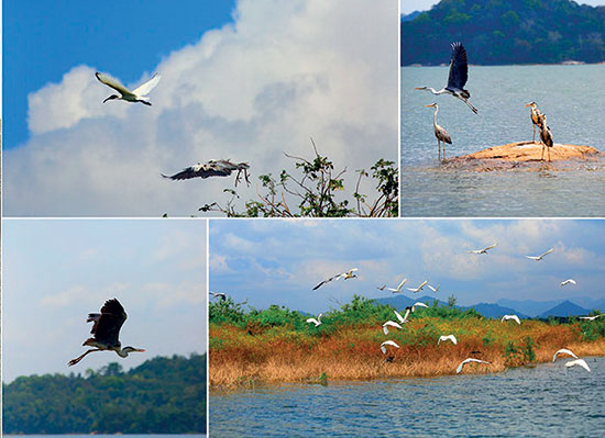
We came across the famous Bagura plains near Kumana. It was a vast extent of land which had been famous for deer, but we did not have the pleasure of seeing a single. The drought was so severe that very little water was seen anywhere. In the party that accompanied me, only my father had been to Kumana before, and therefore only he knew what was where. Kumana was famous for birds, but we saw only a few of them.
The road was in a pretty poor condition, and this made the journey very tiring. We finally came to the former Kumana campsite. We were surprised to see two buildings namely a kovil or Hindu temple built on the bank of Kumbukkan Oya and a sales outlet nearby, which had not been there some years ago.
We traveled a little further down Kumbukkan Oya and had our lunch. The water in the river was stationary as in a lake, for its mouth (moya kata) had been blocked with sand due to the drought. It was a serene sight, with the thick jungle on either side and the blue sky reflected off the still waters.
One could just imagine how the campers of days gone by would have enjoyed their stay here. Of course, the water that remained was too stagnant for a bath, though it was most inviting to wash off one’s tiredness. After lunch we turned back to return to Arugam Bay. On the way at dusk we saw around ten jackals in a pack running back and forth across the road, probably looking for food. I managed to spot five elephants during the entire trip. My father informed me later that he had been to Kumana on several occasions, but he had never seen an elephant. I was quite pleased with myself on hearing this.
We noticed farmers burning logs on the side of the road near the paddy fields. These fields cover a large area and extend as far as the eye could see. I understand that a group of owners get together and light similar fires right round the paddy field in order to prevent elephants from destroying the crop.
I did a more recent trip to Kumana in the latter part of December 2002. While returning at night, I noticed a tusker feeding in a paddy field, while the house in which the owners lived was quite close by.
This was just outside Arugam Bay. When questioned why she did not chase away the elephant, the woman in the house mentioned that in that case the tusker would pull down her hut. Fortunately for her, the elephant was disturbed by our vehicles, and he jumped over the barbed wire fence and left the field.
The following morning we left for Gal Oya from Arugam Bay through Siyambalanduwa. While traveling we saw Govinda Hela, a mountain which the British called Westminster Abbey. Further away was another mountain, known as Vadinagala, which was seen even from the campsite in Gal Oya National Park.
After a drive through scenic country, we arrived at Inginiyagala in the Gal Oya valley. Here we stopped to have a look at Senanayake Samudra. The meaning of Samudra is “sea”. It most probably would have looked like a sea had it been full of water. Unfortunately the water level was well below average due to the drought that was prevailing at the time. Most of the rocks at the bottom of the tank too were exposed.
I have seen pictures of myself as a small child going with my parents and brother in a launch on Senanayake Samudra. I have my doubts that this facility is still available considering the security factor. This has been the first reservoir to be built after independence by D.S.Senanayake, the first Prime Minister of the country.
The vegetation within the park was quite green unlike that in Yala, Udawalawe and Kumana. One reason for this greenery may be the availability of water in Senanayake Samudra, which is in the centre of the park. The place was quite damp and cool.
In all probability there was only one motorable road within the park and there were no bungalows. After a drive of about two miles, we reached the campsite. While we were relaxing at the campsite I spotted two elephants with two babies in the far distance. After a short while we proceeded to Ampara. The heat was unbearable as it was 38 degrees C. On the way to Akkaraipattu we visited Deegavapiya Chaitya, which is said to have been built by King Saddhatissa 400 years after Lord Buddha’s demise.
In Sri Lanka there are supposed to be six medicinal troughs (beheth oruwa). A cavity in the shape of a human being is carved out of one piece of solid rock. In ancient times this cavity was filled with medicinal fluids, such as oils, milk and herbal mixtures, and the patient was immersed in it. One of the oldest medicinal troughs had been found in Deegavapiya.
My father was very keen on seeing it, but what we saw was something we never expected. It was lying as a heap of broken stone fragments in a corner of the temple. According to the chief monk, this trough was located about a quarter mile from the temple, and he had decided to relocate it in the museum at the temple premises. He had been in the process of getting ready to have it transported, when this historical piece of artwork had been blasted into several pieces with the use of explosives by some persons, whose identity was known to him.
We came back to Arugam Bay via Akkaraipattu, and on the way we passed through Sinharamuthuvaran, where a very attractive cadjan-roofed resthouse once stood, as well as Komari of Kavantissa fame. We returned to Colombo the next day.
Yala Block two
Block two of the Ruhuna National Park, which was seen across Kumbukkan Oya at Kumana, could be entered from Yala. I remember travelling this way in May 1992. When our Land Rover was being taken across Menik Ganga at Nana Thotupola, the vehicle stalled in the middle of the river due to its wheels getting stuck in the sand. Every effort was made to pull it out the vehicle with the help of the accompanying four-wheel drive pick-up,’ as well as that of about 25 men who were bathing in the river at the time, but to no avail.
Finally success was achieved with the help of the Land Rover’s winch, which was hooked on to the back of the stationary pick-up. Having thus entered Block two, we then proceeded a short distance till we came to Katupila Ara, which too had to be forded. I remember my brother-in-law wading across to check the path the vehicles should take.
Having safely crossed over, we came across a small water-hole where we saw a remarkable sight which was never before witnessed by any of us present. Though there were people in the party who were highly experienced in the ways of the jungle, this sight was unique to them too. There were over a hundred crocodiles of all sizes sun bathing all round the water-hole. They all crawled hurriedly into the water on the approach of the vehicle, and there was not even a ripple on the surface of the water to show that there were so many crocodiles in that small water-hole.
If a small animal, such as a deer, ventured there for a sip of water it would no doubt have been an easy prey. Having witnessed this scene, we realized that my brother-in-law had faced much danger from crocodiles in wading across Katupila Ara.
Further on, we came to Pottana where we saw a fresh water well built with masonry. It was an unusual sight in a jungle without human habitation. My father told us that it was a well that was built for the use of pilgrims on their way to Kataragama from Potuvil. This has been the path where a man-eating leopard had been lying in wait many years ago to attack sick and decrepit pilgrims.
In 2002 we repeated the trip. The water level in Menik Ganga was quite low and it was smooth sailing for the three pick-ups to cross over to the other side. On this occasion no one dared to test Katupila Ara before the vehicles crossed. The water was almost up to the bonnets and the windscreens did get washed in the process. We saw a huge bull elephant and a lot of buffalo grazing not too far from us. The road to Pottana was really bad. At a certain point I thought that each vehicle would topple on to its side.
Pottana Pitiya was a vast dry plain with thin vegetation. Beyond this was the lagoon and then the sea. We met a couple of visitors with a tracker cooking their lunch near the sea. They were kind enough to offer us some fried prawns as a snack. Unlike on the previous occasion we did not come across the small water-holes or the well of fresh water. Most probably we would have taken a parallel route.
On our return journey, we found that the water level in Katupila Ara was higher than in the morning. We crossed it with difficulty, the engine just escaping being flooded by the depth of water. On the other side of the Ara, we found a jeep which had been immobilized by water getting into the engine.
They had brought a mechanic from Tissamaharama to repair it. It was quite late in the evening and there was no sign of getting the engine started. Later we heard that the jeep had been towed the next morning for a major repair.
It was late in the evening when we reached Menik Ganga. We were so glad to see Block two after a lapse of 10 years.
In February 2004, while camping at Yala, we once again entered Block two. Proceeding northwards, we forded Katupila Ara, Pottana Ara and finally the broad Kumbukkan Oya, to reach Kumana. After visiting Kumana villu, we returned to Yala the same evening. It was a memorable journey, having passed through perhaps the most extensive plains I have seen.
Yala Blocks three, four and five
The North Intermediate Zone was absorbed into the Ruhuna National Park. This step was taken when the government in 1964 banned the issue of licenses to shoot animals, thereby making the presence of Intermediate Zones where shooting was allowed, meaningless. This annexure was divided into Blocks three, four and five. The Department of Wildlife Conservation built a bungalow in Dambakotte in Block four, which was reached by travelling along the Buttala – Kataragama highway.
We left Colombo on December 21, 1996 and reached Dambakotte bungalow, where we were to stay three nights. The bungalow, which was about a kilometre from the road, was surrounded by tall jungle trees, while underneath them was a carpet of beautiful grass which was of a special green. About a kilometre further into the jungle was a tank, which we visited several times during our stay, but failed to see any significant wildlife except several varieties of water birds.
This area was said to be rich in bear population though we did not see any. However, we heard the loud mating call of a bear quite close to the bungalow at about 11 o’clock in the night. The noise faded away into the distance in a few minutes.
Block 3
We traveled to Galge, which was about five km from Dambakotte. About 200 yards away from the quarters and offices of the Department of Wildlife Conservation was an extensive slab of rock where there was a large natural water-hole or kema, which probably never ran dry during the drought. The employees used to draw their regular supply of water from this water-hole. On our way to this water-hole, a large wild boar accompanied us, and we thought it was a pet of the men working there. Little did we realize the danger we were in till we were told that it had attacked a police inspector a few days earlier and he was still being treated in hospital at the time.
The water-hole had caved into the rock sideways to form a very large cavity, while the opening into the exterior remained comparatively small. By these means only a small area of water was exposed to the sun, thereby reducing the amount of water that would evaporate. This contrivance probably accounted for the failure of the drought to dry the water-hole.
The impressive Ireson tower stood on a rock some distance from the water-hole. We reached it by shuffling along the narrow stony ledge of the water-hole with difficulty. This tower was an outstanding memorial to J P Ireson, who died of diarrhoea in 1922 at Monaragala, where he was planting. He was president of the Wildlife Society at the time, and it built this memorial to him at Galge, which could only be reached on foot or horseback at the time.
Ireson was an inveterate hunter, who used to come down frequently from Monaragala to hunt around Galge, which therefore was selected as the site for the memorial. However, on questioning the average man there, the answer would invariably be that it was a monument to an Englishman killed by an elephant at that spot.
From Galge we went through thick jungle, along the only available jeep track in Block three. In view of the many obstacles that greeted us, this track had not been used for a long time. We reached a large rock known as Paskema (five water-holes). Its surface had several water-holes of different sizes, some with beautiful lotus flowers, but it probably received its name from the fact that there were five significant water-holes in it. On climbing the rock we could see the jungle far and wide, the trees being festooned with flowers, young leaves turning crimson and woody creepers hanging heavily on branches.
Malwarikema
Continuing the journey, we came to Malwariweva which was a tank that had been renovated a short time earlier. We walked along the bund and saw pits on it which were produced by elephants whose feet had sunken into the earth as they descended into the water.
Further on, we came to Malwarikema that had, as its name implied, a water-hole which appeared beautiful with blossoming lotus. This was apparently an old monastic site. An unusual finding on it was the presence of two cone-shaped pits, several yards apart from each other. Each measured about eight inches in diameter and six inches in depth, and they were exactly circular and the walls perfectly smooth. The tracker who accompanied us explained that they were pits in which treasures were hidden in the olden days, and that treasure hunters had raided them and removed the contents.
It was difficult to believe this story. The pits were not large enough to hide such treasures, and it was unlikely that rainwater would be prevented from seeping in. It is a moot point how treasure hunters would have located them once the contents had been sealed off by the owners centuries ago.
Block five
The Buttala – Kataragama highway does not exactly follow the old jeep track, as it deviated about a hundred yards at certain points. The jungle that lies between this highway and the Menik Ganga is Block five. We had a bath in the river at a place at which two tributaries joined to form the main river. This was the point at which the elephants from Handapangala crossed the river when they were driven into Block four by the Department of Wildlife Conservation. The wisdom of this man oeuvre is open to question, for several elephants died subsequently.
Indikolaweva was a tank in Block five which had been recently renovated. On the bund was an elongated piece of dung, which the tracker identified as that of a crocodile. He mentioned that it was rather poisonous to the skin, for blisters may form when trod on. On the other side of the long bund, we saw an elephant, while a tall tree nearby was crowded with hornbills. We did not see any other animals of significance, and this was true of all these Blocks. One reason for this scarcity of animals was probably the presence of tall jungle trees in the areas we visited.
(concluded)
(Excerpted from Jungle Journeys in Sri Lanka edited by CG Uragoda)
Sri Lanka is one of the up-and-coming surf gems of South Asia. Everything from crumbly beginner breaks to rippable points is on the menu, and there are tangy eggplant curries and mist-shrouded tea fields to get stuck into when you’re finished.
With one coast facing the open Indian Ocean and the other peering into the Bay of Bengal, Sri Lanka has a seriously enviable location for hitting the waves. Both sides of the island work at different times of the year – the southwest in the winter, the east in the summer. On top of that, the vibe is mega chilled, with reggae-surf bars dotting the shorelines and boho surf camps welcoming all levels.
Wondering where to surf in Sri Lanka? Look no further than this guide, which scours both halves of the Teardrop for the eight top spots.
(Extract. AbaY relevant ) :
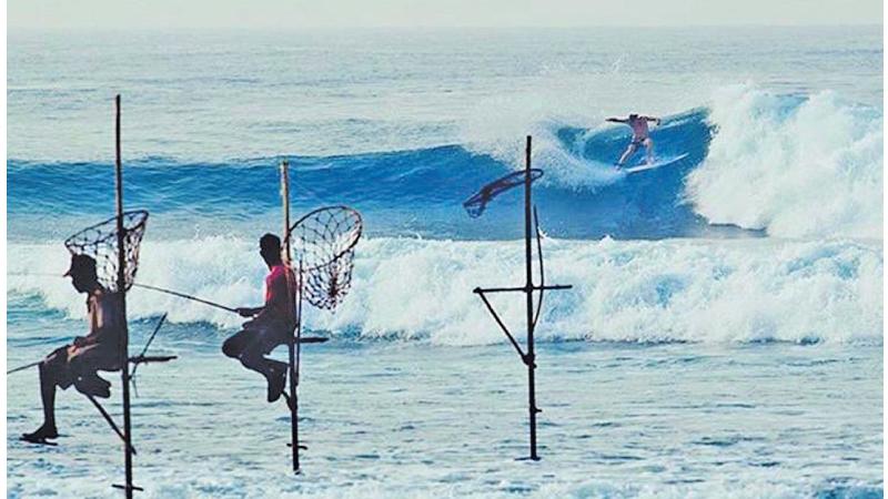
Arugam Bay: the place to surf from May to October
Arugam Bay is the surf town of choice during the south-western monsoon. That brings rough ocean currents and loads of rain to pretty much all the other places on this list between May and October. All the while, the east coast of the island where A-Bay – as it’s come to be known – makes its home gets blessed by regular groundswells and sun-filled days.
There’s a whole string of breaks on the menu here. Closest to the town, the right-hander of Main Point is a cruisy ride of up to 150m (492ft) on the best days. To the south, there’s Peanut Farm, the beginner’s choice, followed by the punchy points of Okanda for the pros.
Arugam Bay has developed into a pretty hefty resort town in the last couple of decades. The road behind the beach is now riddled with curry houses and beer bars, which can become pretty lively in the peak of the summer. SAFA Surf Camp is probably the best-known tuition provider, with packages for all levels.
Getting to Arugam Bay: A taxi from the airport to Arugam Bay takes about 5 hours and costs about 18,000-25,000? Air con Bus Colombo to AbaY: Rs./ 2,000
Sri Lanka is gifted with some of the best beaches in Asia as well as in the world that is wholesome in every aspect to name as great. It is also the reason that Sri Lanka has become one of the major travelling destinations for foreigners who are seeking to get some sunshine basking on a beautiful beach.
As a result more and more visitors are flowing to these Sri Lankan shores every year and many of them are surfers. The attraction and arrival of these foreign surfing communities are one of the main reasons behind owning a growing surf culture in Sri Lanka. The major reason for the success of the industry is the specific beaches that Sri Lanka has which are extremely suitable and popular as surfing destinations across the globe like Arugam Bay, Weligama, Hikkaduwa and Mirissa. Having more beautiful geological, archaeological and natural surroundings across the country also has been an extra benefit for Sri Lanka when we talk about tourist attractions to the island nation.
The next reason behind the success is the excitement created around the topic of surfing recently and which has been influential to create a buzz among the foreign crowd and locals. The establishment of the Surf Federation and the launch of the National surfing contest and some government involvements also have been the major reasons behind this success.
Although the private sector has not paid much attention to surfing, Red Bull fired the first shot through their Red Bull Ride My Wave. The Red Bull energy drink company has come as light in a tunnel that barely gets light and the Red Bull company is making a tremendous effort to increase the level of quality and make surfing in Sri Lanka more enjoyable and competitive. For the last six seasons Red Bull has proved that the event is successful and its importance for the sport to move forward and that is one of the major reasons that upheld the success in the sport in the country.
Sri Lanka is blessed with pristine beaches and perfect conditions in the ocean to create waves. Sri Lanka is more popular for its small wave surfing and this is great to attract every level of surfers from starter in the sport to the pros. The Southwest of Sri Lanka offers mellow beach breaks that create the vibe suitable for beginners like Weligama and Dewata. These small waves are pretty easy to manage and safe to ride for beginners and one of the best places to start as a surfer. This reason has been helpful to establish more surfing schools around the coastal line. Moreover surfers can surf Sri Lanka throughout the year depending on the time period of the year. The southwest season runs from November through to April while the northeast season runs from April to October.
The southwest of Sri Lanka also offers punchy A-Frame reef breaks such as the Hikkaduwa main reef, Kabalana The Rock and Madiha left. Surfing on the East coast, especially in Arugam Bay it is all about leg-burning long right-hand point breaks, every surfer’s dream. More experienced and fun-seeking people are flocking towards Arugam Bay every year and recently it was recognized as an international level surfing point where a lot of international fame has been floated towards.
The peak of Arugam Bay fame was acquired when the first international competition was organized in Arugam Bay in 2018. Annually the Sri Lankan national championship is also held in Arugam Bay and all these reasons are buckled up to bring fame and attraction from the international surfing community to Sri Lanka. Source: http://www.sundayobserver.lk/2022/04/04/sports/why-surfing-suitable-sri-lanka-and-its-success
Arugam Surf on Facebook. Join our 155,000+ friends!
Disclaimer
Arugam.info is a fully interactive site.
It is not moderated or censored.
Therefore, all views expressed and posted here are the opinion of the individual author.
Automatic publication on this site does not constitute endorsement with any point of view or opinion expressed.
We do wish, however, to remain:
Non Political
Non Religious
Non Violent
But we may well continue to be:
Critical of anyone who could do better
Do you like Old Arugam Bay?
Here you find any article ever written about Arugam Bay
Meet great people on our FB page
Arugam Bay:
Nobody can simply 'just'
GO TO ARUGAM !
YOU first have to EARN it.
After coming thru our jungles, Dodging Wild Elephants,
Crossing crocodile infested lagoons & rivers,
Passing Old Check Points and
Burned down Houses:
You will have a sense of achievement
When you reach remote AbaY!
Arugam.Info is a free Self-help Community page.
We attempt to publish and re-publish every article and every report ever written about our small, remote village.
The idea is to make it easy and simple for you to decide, if this is a resort for YOU.
An upcoming and most promising, beautiful Bay with a lot of untapped potential:
This is what we wish to share with you.
And try to attract you to visit us.
If you like, what you see here, join our popular Facebook Fan Club, too!

 Arugam Forum
 Arugam Photo Galleries on Picasa
 Old Website
 Press Coverage
 Surf Forecast for Arugam Bay
TODAY’s Comments